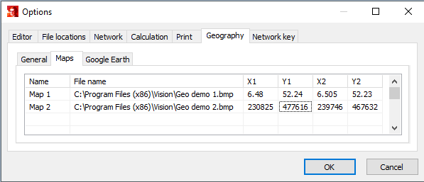
The network can be displayed on a geographical background. Under General, you can specify which objects should be shown. Here it can also be indicated whether intermediate points and joints of cables should be shown. The geographical background can be:
•Maps: a bitmap image, with recorded coordinates of the vertices. The coordinates can either be given in the EPSG:28992 or in the decimal-degree coordinate system. The size of the geographical background is defined in the graphical properties of the bitmap image.
•Google Earth: nodes, cables and joints are shown in Google Earth through the use of a kml-file.
Map (bitmap)
First, the geographical background must be defined. In the options, the map files (only bitmap images) can be specified with the X and Y coordinates of their corner points. The parameters X1 and Y1 represent the vertex of the top left corner and the parameters X2 and Y2 represent the vertex of the bottom right corner. The example below shows a map definition in decimal geographic coordinates (Map 1) and a map definition in EPSSG:28992 coordinates (Map 2). See: Tools Maps

Parameter |
Description |
Name |
Name van de graphical layer during usage |
File name |
Full path and name of the graphical layer bitmap file |
X1, Y1 |
X- and Y- coordinate of the upper left corner |
X2, Y2 |
X- and Y- coordinate of the lower right corner |
The coordinates can be entered in the EPSG:28992 coordinate system or in the decimal-degree coordinate system.